Staff:
Nick Brozek - Director of Planning and Environmental Services
Jeanette Pidde - Land Use and Zoning Supervisor
Brent Lang - Ditch and Ag Inspector
Matt Mumme - Assistant Ditch and Ag Inspector
Chris Burchfield - GIS Specialist
Adam Kletscher - Plum Creek County Park Ranger
Lali Ortega - Administrative Assistant and Ditch Technician
Forms
Planning and Zoning
It is the duty of the Environmental Office to administer and enforce the Redwood County Zoning Ordinance. We strive to work within the requirements of our zoning ordinance and other applicable laws to accommodate the citizens of Redwood County to ensure logical, consistent, and reasonable results and to maintain orderly growth and development in the county.
Other Services
Septics
Overview
The Environmental Office is charged with ensuring that septic systems installed throughout the County are designed, constructed, and installed correctly so that they do not pose a threat to human health or the environment. Septic systems are effective at processing human waste and preventing pollution when they are installed and maintained correctly. The County works closely with landowners when new systems are installed or old systems are replaced to ensure that they will function properly. No septic system may be installed without being approved by the County.
What we do?
- We review and approve all septic system designs to make sure they are in compliance with the septic ordinance
- We conduct onsite inspections
- Soil inspection prior to design
- Inspection when septic tank is set in the ground
- Inspection when the distribution pipes are laid in the ground
- We assist landowners with questions about system operation and maintenance
- We provide low interest loans and low income grants to assist individuals with upgrading non compliant or failing systems.
Helpful Materials
GIS
What is GIS?
GIS stands for “Geographic Information System” and it is a system designed to capture, store, manipulate, analyze, manage, and present all types of spatial or geographical data. If you have ever used google maps to find an address, or the closest gas station, you have seen GIS in action. GIS is simply information with a location.
Overview
The Redwood County Environmental Office is tasked with maintaining, improving, and creating digital databases relevant to the County. This can include infrastructure, land use, land cover, administrative or political boundaries, demographics, environmental, emergency management, and any other data which can be combined with a geographically referenced location. GIS is a valuable tool to manage large systems and provides a way to display large amounts of data in an easy to understand fashion.
Our Office maintains all of our digital spatial data in a way that it is accessible and useful to other County Departments as well as the residents of Redwood County. It is difficult to adequately explain how important GIS is to the functioning of a modern government organization. The value we derive from GIS is only going to increase, and our investments now should pay off well into the future.
Access Beacon Online GIS
GIS to the Public
![]() In 2016, Redwood County launched a new service, which provides the general public with access to our GIS data. Beacon™ was the product chosen by the County to provide this service. Beacon™ is an online interface that allows users to interact with data uploaded by Redwood County. This data is in the form of “layers” that includes our roads, parcel information, waterways, public drainage, political lines, and more. Beacon™ takes this data and represents it on high quality interactive imagery which makes it highly accessible to the public.
In 2016, Redwood County launched a new service, which provides the general public with access to our GIS data. Beacon™ was the product chosen by the County to provide this service. Beacon™ is an online interface that allows users to interact with data uploaded by Redwood County. This data is in the form of “layers” that includes our roads, parcel information, waterways, public drainage, political lines, and more. Beacon™ takes this data and represents it on high quality interactive imagery which makes it highly accessible to the public.
Drainage
Overview
Redwood County maintains the Public Drainage System that was established under MN Statute 103E. This includes County drain tile and County ditches. The Drainage Inspector maintains the drainage system by performing timely repairs and maintenance to keep the systems working efficiently. The repairs are done by private contractors.
There are over 520 miles of County open ditches and over 1100 miles of County tile lines in Redwood County. The County Drainage system is funded by those who benefit from the system as determined by “viewers”. When the drainage systems were established, “viewers” went out and determined by quarter quarters what land was going to be benefiting from the new drainage. Using a formula based on soil types, slope, and proximity to the ditch and tile, dollar amounts are assigned to each quarter quarter (40 acres). When work is conducted on a drainage system the individuals who are benefiting are assessed the cost based off their benefits in proportion to the system as a whole.
Helpful Materials
Drainage Proceedings
Redetermination Landowner Meetings: You Tube Channel
Aquatic Invasive Species
Overview
In 2014 the MN Legislature passed a bill providing $10 million to Minnesota counties to support Aquatic Invasive Species (AIS) prevention programs. Redwood County receives approximately $20,000 / year in funding. Redwood County has adopted a AIS Prevention Plan which outlines the steps the County is going to take. Our prevention plan focuses on awareness and public education.
What are AIS?
Species such as Asian Carp, Zebra Mussels, Milfoil, and others, threaten to change the way we interact with our waters. Aquatic invasive species (sometimes called exotic, invasive, nonindigenous or non-native) are aquatic organisms that invade ecosystems beyond their natural, historic range. Their presence may harm native ecosystems or commercial, agricultural, or recreational activities dependent on these ecosystems. They may even harm our health.
Helpful Materials
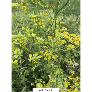
Noxious Weeds
Overview
The Redwood County Environmental Office oversees the enforcement of Minnesota’s Noxious Weed Law. Some plants are considered noxious because they cause harm to people, animals and or the agricultural industry. It is the legal responsibility of all landowners, the person who occupies the land, or the person responsible for or charged with the maintenance of public land to comply with the noxious weed law on their property.
The public is asked to control and eradicate noxious weeds in order to keep them from spreading and harming neighboring lands. Failure to comply with the Inspectors notice to control noxious weeds are in violation of the Noxious Weed Law and are subject to the County contracting to complete the work, with all costs being added to their property taxes, or a summons to district court.
You do not have to remove noxious weed materials from your property. It is preferred that you leave materials on site and either destroy them by a legal means or allow to naturally degrade. The Minnesota Noxious Weed Law does not require removal of listed species from your property. It simply requires eradication (killing the plant) or control (preventing seed production and spread) – depending on the regulatory designation for each species. The goal of the law is to prevent the growth and spread of harmful plants to new areas. Removal from your property increases the potential of accidentally spreading these plants while transporting them. Land with established weed infestations already has a viable seed bank, i.e., seeds that are deposited into the soil from past generations that are dormant. Therefore, keeping plants on site to naturally decay is the best and safest method to prevent future spread to new areas.
While some noxious weeds are distinctive and easily recognized, many others are difficult to distinguish from one or more of our native species. For identification questions, please contact Redwood County Ag Inspectors, Matt Mumme or Brent Lang at (507) 637-4023.
Resources
Buffer Law
Ordinance
Informational Links
